![](/images/other/stat-length.png)
![Percorso A piedi Bad Urach - Hochbergsteig - Photo](https://media.geolcdn.com/t/1900/400/4a7dba79-0391-40d1-9faf-9ad41e0a6f30.jpeg&format=pjpeg&maxdim=2)
Hochbergsteig
SityTrail - itinéraires balisés pédestres
Tous les sentiers balisés d’Europe GUIDE+
![Lunghezza](/images/other/stat-length.png)
Lunghezza
7,5 km
![Altitudine massima](https://static1.geolcdn.com/siteimages/upload/files/1508320355ic_sort_altitude_max_24dp.png)
Altitudine massima
738 m
![Dislivello positivo](https://static1.geolcdn.com/siteimages/upload/files/1508320355ic_sort_den_pos_24dp.png)
Dislivello positivo
314 m
![Km-Effort](/images/other/stat-length.png)
Km-Effort
11,6 km
![Altitudine minima](https://static1.geolcdn.com/siteimages/upload/files/1508320355ic_sort_altitude_min_24dp.png)
Altitudine minima
470 m
![Dislivello negativo](https://static1.geolcdn.com/siteimages/upload/files/1508320355ic_sort_den_neg_24dp.png)
Dislivello negativo
277 m
![Boucle](https://static1.geolcdn.com/siteimages/upload/files/16400158638029165_repeat_loop_refresh_sync_direction_icon.png)
Boucle
Sì
Tag
Data di creazione :
2022-02-11 17:56:05.612
Ultima modifica :
2022-02-11 17:56:05.612
![A piedi](https://static1.geolcdn.com/sitytour/trail-icons/100.png)
2h37
Difficoltà : Facile
![Scannerizza questo codice QR per aprire il percorso nell'applicazione SityTrail](https://capi.geolives.com/qq0zvz2zws4bq2lad0pu/sitytour/trails/3098784/qr.png?size=200)
Applicazione GPS da escursionismo GRATUITA
Chi siamo
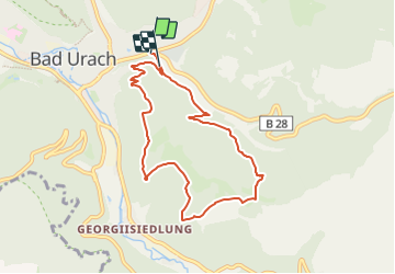
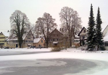
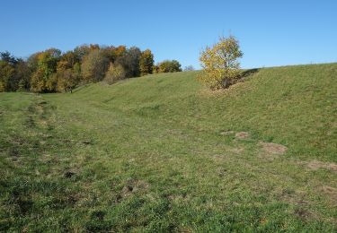
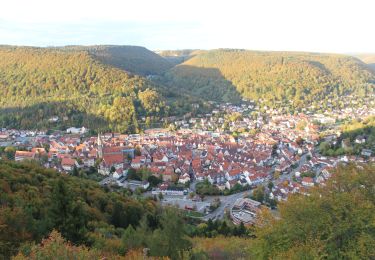
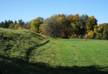
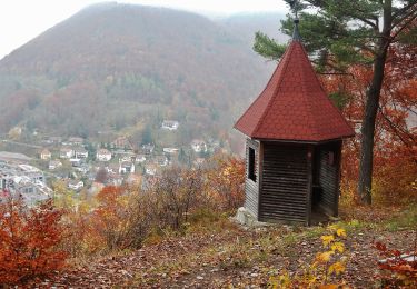
Percorso A piedi di 7,5 km da scoprire a Baden-Württemberg, Landkreis Reutlingen, Bad Urach. Questo percorso è proposto da SityTrail - itinéraires balisés pédestres.
Descrizione
Die Grafensteige: fünf traumhafte Rundwanderwege im Albtraufbereich, die zu den Naturschönheiten der Schwäbischen Alb führen.
Localizzazione
Paese:
Germany
Regione :
Baden-Württemberg
Dipartimento/Provincia :
Landkreis Reutlingen
Comune :
Bad Urach
Località :
Unknown
Partenza:(Dec)
Partenza:(UTM)
530300 ; 5371322 (32U) N.
Commenti
Percorsi nelle vicinanze
![Percorso A piedi Gomadingen - hochgehsiedelt - Photo](https://media.geolcdn.com/t/375/260/ddeecde5-3ad4-49f8-9dbd-9619c6cd1200.jpeg&format=jpg&maxdim=2)
![A piedi A piedi](https://static1.geolcdn.com/sitytour/trail-icons/100.png)
hochgehsiedelt
A piedi
Facile
Gomadingen,
Baden-Württemberg,
Landkreis Reutlingen,
Germany
![](/images/other/stat-length.png)
4,5 km | 5,2 km-effort
1h 10min
![](https://static1.geolcdn.com/siteimages/upload/files/16400158638029165_repeat_loop_refresh_sync_direction_icon.png)
Sì
![Percorso A piedi Gomadingen - hochgehflogen - Photo](https://media.geolcdn.com/t/375/260/888ed909-a23d-4dca-8b36-5989f4832cd6.jpeg&format=jpg&maxdim=2)
![A piedi A piedi](https://static1.geolcdn.com/sitytour/trail-icons/100.png)
hochgehflogen
A piedi
Facile
Gomadingen,
Baden-Württemberg,
Landkreis Reutlingen,
Germany
![](/images/other/stat-length.png)
10 km | 13,6 km-effort
3h 5min
![](https://static1.geolcdn.com/siteimages/upload/files/16400158638029165_repeat_loop_refresh_sync_direction_icon.png)
No
![Percorso A piedi Gomadingen - Fischburgtal - Zainingen - Photo](https://media.geolcdn.com/t/375/260/583d2710-4cbb-40f2-896d-467f9518cb7e.jpeg&format=jpg&maxdim=2)
![A piedi A piedi](https://static1.geolcdn.com/sitytour/trail-icons/100.png)
Fischburgtal - Zainingen
A piedi
Facile
Gomadingen,
Baden-Württemberg,
Landkreis Reutlingen,
Germany
![](/images/other/stat-length.png)
7,2 km | 9,4 km-effort
2h 7min
![](https://static1.geolcdn.com/siteimages/upload/files/16400158638029165_repeat_loop_refresh_sync_direction_icon.png)
No
![Percorso A piedi Gomadingen - Fleggaronde - Photo](https://media.geolcdn.com/t/375/260/59a2e980-7250-410f-a2f0-ce22858309a7.jpeg&format=jpg&maxdim=2)
![A piedi A piedi](https://static1.geolcdn.com/sitytour/trail-icons/100.png)
Fleggaronde
A piedi
Medio
Gomadingen,
Baden-Württemberg,
Landkreis Reutlingen,
Germany
![](/images/other/stat-length.png)
23 km | 27 km-effort
6h 5min
![](https://static1.geolcdn.com/siteimages/upload/files/16400158638029165_repeat_loop_refresh_sync_direction_icon.png)
No
![Percorso A piedi Gomadingen - Hohenurachsteig - Photo](https://media.geolcdn.com/t/375/260/b833acbe-035b-4645-8816-ed407bb4ac6d.jpeg&format=jpg&maxdim=2)
![A piedi A piedi](https://static1.geolcdn.com/sitytour/trail-icons/100.png)
Hohenurachsteig
A piedi
Facile
Gomadingen,
Baden-Württemberg,
Landkreis Reutlingen,
Germany
![](/images/other/stat-length.png)
7,4 km | 12,8 km-effort
2h 54min
![](https://static1.geolcdn.com/siteimages/upload/files/16400158638029165_repeat_loop_refresh_sync_direction_icon.png)
Sì
![Percorso A piedi Gomadingen - Nebenweg des Schwäbischen Albvereins (rote Gabel) - Photo](https://media.geolcdn.com/t/375/260/2744b40e-5d98-4d86-8cf9-dfff79cb1b48.jpeg&format=jpg&maxdim=2)
![A piedi A piedi](https://static1.geolcdn.com/sitytour/trail-icons/100.png)
Nebenweg des Schwäbischen Albvereins (rote Gabel)
A piedi
Facile
Gomadingen,
Baden-Württemberg,
Landkreis Reutlingen,
Germany
![](/images/other/stat-length.png)
6,3 km | 8,4 km-effort
1h 53min
![](https://static1.geolcdn.com/siteimages/upload/files/16400158638029165_repeat_loop_refresh_sync_direction_icon.png)
No
![Percorso A piedi Gomadingen - Kleine Schrecke - Schlattstall Nebenweg des Schwäbischen Albvereins (rote Gabel) - Photo](https://media.geolcdn.com/t/375/260/2744b40e-5d98-4d86-8cf9-dfff79cb1b48.jpeg&format=jpg&maxdim=2)
![A piedi A piedi](https://static1.geolcdn.com/sitytour/trail-icons/100.png)
Kleine Schrecke - Schlattstall Nebenweg des Schwäbischen Albvereins (rote Gabel)
A piedi
Facile
Gomadingen,
Baden-Württemberg,
Landkreis Reutlingen,
Germany
![](/images/other/stat-length.png)
4,5 km | 5,8 km-effort
1h 18min
![](https://static1.geolcdn.com/siteimages/upload/files/16400158638029165_repeat_loop_refresh_sync_direction_icon.png)
No
![Percorso A piedi Bad Urach - Hengen - Urach Innerer Zugangsweg Schwäbischen Albvereins (gelbes Dreieck) - Photo](https://media.geolcdn.com/t/375/260/8fc03902-8d4e-45fd-a5bf-9eecfd5c824e.jpeg&format=jpg&maxdim=2)
![A piedi A piedi](https://static1.geolcdn.com/sitytour/trail-icons/100.png)
Hengen - Urach Innerer Zugangsweg Schwäbischen Albvereins (gelbes Dreieck)
A piedi
Facile
Bad Urach,
Baden-Württemberg,
Landkreis Reutlingen,
Germany
![](/images/other/stat-length.png)
7,1 km | 10,6 km-effort
2h 24min
![](https://static1.geolcdn.com/siteimages/upload/files/16400158638029165_repeat_loop_refresh_sync_direction_icon.png)
No
![Percorso A piedi Gomadingen - Innerer Zugangsweg Schwäbischen Albvereins (gelbes Dreieck) - Photo](https://media.geolcdn.com/t/375/260/399ab1ee-b650-4414-bef5-300f83920479.jpeg&format=jpg&maxdim=2)
![A piedi A piedi](https://static1.geolcdn.com/sitytour/trail-icons/100.png)
Innerer Zugangsweg Schwäbischen Albvereins (gelbes Dreieck)
A piedi
Facile
Gomadingen,
Baden-Württemberg,
Landkreis Reutlingen,
Germany
![](/images/other/stat-length.png)
4,1 km | 4,8 km-effort
1h 5min
![](https://static1.geolcdn.com/siteimages/upload/files/16400158638029165_repeat_loop_refresh_sync_direction_icon.png)
No